Application of Multi-Angle Imaging Spectro Radiometer in Agricultural in Middle Gujarat for Wheat Crop
H. K. AHIR and B. M. Mote
Dept. of Agricultural Meteorology, Anand Agricultural University, Anand- 388 110
DOI : http://dx.doi.org/10.13005/ojcst/9.02.10
Article Publishing History
Article Received on :
Article Accepted on :
Article Published : 19 Aug 2016
Article Metrics
ABSTRACT:
The present analysis was carried out using the satellite image from the Multi-angle Imaging Spectro Radiometer (MISR) was acquired over Middle Gujarat on 9 and 18 February 2015. The MISR is one of the five instruments on board the EOS/ Terra spacecraft. The Rahaman-Pinty-Verstraete inversion and Forward semi-empirical three parameters leaf reflectance shape (rho0), the curve convexity (k) and the dominant forward scattering (Ɵ) model were used to simulate angular patterns of BRF for wheat on 18 February 2015. The potential of the RPV model to represent the BRF of leaves in the 400-1100 nm spectral range was investigated in this study. The results revealed that the variety of tests are shown in order to document and analyse software performance against simulated BRF fields by RPV anis view model as well as against actual MISR-derived satellite BRF was blue, green and red good match with each but mismatched with NIR and all MISR band blue, green and red and NIR for mature wheat.
KEYWORDS:
present; analysis; Middle; Gujarat
Copy the following to cite this article:
AHIR H. K, Mote B. M. Application of Multi-Angle Imaging Spectro Radiometer in Agricultural in Middle Gujarat for Wheat Crop. Orient.J. Comp. Sci. and Technol;9(2)
|
Copy the following to cite this URL:
AHIR H. K, Mote B. M. Application of Multi-Angle Imaging Spectro Radiometer in Agricultural in Middle Gujarat for Wheat Crop. Orient. J. Comp. Sci. and Technol;9(2). Available from: http://www.computerscijournal.org/?p=3826
|
Introduction
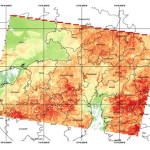
The multi-angle imaging Spectro Radiometer (MISR) is innovative instrument that uses simultaneous multi-angular measurements to obtain angular reflectance information for retrieval of geophysical parameters Diner et al. (1991).MISR provides near-concurrent multiple view of a surface at several viewing geometries with spatial resolution of 275 m and 1.1 km. Considering the satellite level evaluations of the TOA BRF signal data of Multi-angle Imaging SpectroRadiometer (MISR)sensor of TERRA satellite chosen to derive measured TOA BRF. The MISR instrument consists of nine pushbroom cameras arranged in different view angles relative to the earth’s surface, and the along-track angles are 0° (nadir) for the An camera, and 26.1°, 45.6°, 60.0° and 70.5° forward and backward of nadir for the Af/Aa, Bf/Ba, Cf/Ca, and Df/Da cameras, respectively for blue, green, red and NIR bands. This band central wavelength 446, 558, 672 and 886nm. Local mode radiance data of the MISR requested to NASA for middle Gujarat region. The MISR science team has added middle Gujarat in the local mode sites of the MISR and local mode data made available since mid-November 2014. The RPV model simulates the anisotropic behaviour of the bidirectional reflectance from a surface using a three terms. The Minneart function is explain the general shape of the angular reflectance: increase with viewing angle (‘bowl shaped’) or decrease with viewing zenith angle (‘ bell shaped’) and also two other terms degree of forward and backward scattering and magnitude of reflectance in the hot spot direction. In the RPV model, a Minneart function parameter k represent the degree of the reflectance function. Pinty et al. (2002) and Widlowski et al. (2001) have shown that the anisotropic reflectance pattern is effected by vegetation structure. the MISR image acquired on 9 and 18 February 2015.
Misr Data
MISR data products provide in processing level. Level 1 data products give information calibrated instrument data. Level 2 products derived quantities such as aerosol, cloud heights and surface reflectance and Level 3 products provide globally gridded statistical summaries of selected all level for different time (monthly, seasonal and annual). NASA Terra platform Multiangle Imaging SpectroRadiometer (MISR) instrument acquires reflectance data from Earth land surface target in four visible spectral bands, from nine different directions, in seven minutes. MISR data are downloaded from the platform at a spatial resolution of 275 m in all bands of the nadir camera and in the blue, green and red band of the off-nadir cameras, (see Diner et al. (1998). The MISR instrument was given information about anisotropic patterns of the spectral radiation scattered by different land covers. As shown in Diner et al. (2005),
Materials and Methodology
This case study focus on a portion region covered in middle Gujarat for wheat crop. MISR nine viewing angles were used to select pixel average for different wheat patches of blue, green, red and NIR band BRF values. This different MISR angles BRF value and MISR Geometric parameter (view zenith, solar zenith, view azimuth, solar azimuth) used to run RPV inversion model. The solar and viewing azimuth used to calculate a relative azimuth for RPV inversion model. The RPV inversion three co-efficient (rho0, k, Θ) and also MISR geometric parameter for all MISR angles of different wheat patches in RPV forward model simulate single BRF value of all MISR angles.
Result and Discussion
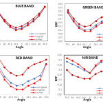
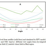
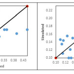
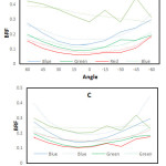
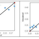
The MISR sensor observed BRF along a single azimuth plane for different wheat field is depicted in Fig. 1 (a, b & c). The RPV model simulations of Blue, Green, Red bands BRFs of wheat canopy were close to the observed as compared to NIR band. Less anisotropy in reflectance of NIR was due to multiple scattering of the radiation in the band within wheat crop canopy. In rainfed wheat of Bhal region (Figure 1 c) BRF of NIR also shows prominent variation with zenith angles while model failed to simulate the same. This might be because of less multiple scattering of NIR in canopy structure of durum wheat (grown in Bhal region). More anisotropic behaviour in canopy reflectance was observed in backscatter direction than in forward scattering direction in all the wheat fields. Overall, RPV model simulation performance is depicted in Figure 2. It revealed that green band BRF simulations were close to the measured values compared to the other band. In blue, the model found failed to simulate higher BRF values. Simulation performance for Red and NIR bands was found poor to average. The RPV model inversion package (3 parameters version) was applied to block 72, 73 (path 148,149) of MISR level 2 surface-derived BRFs (terrain-projected) showing contrasted surface conditions
The MISR instrument thus samples the information related to the anisotropic patterns of the spectral radiation scattered by various types of land surfaces. As shown in Diner et al. 2005, these angular signatures can be used to obtain unique information about the geometric and physical properties of the environment. Specifically, under favorable conditions of illumination and background brightness, the BRF field in the red spectral domain can assume a bell-shape pattern. When this occurs, the k parameter of the RPV model takes on values larger than unity, and this has been interpreted as indicating the presence of dark vertical structures such as trees over a relatively bright background at the MISR subpixel scale also use Nolin, 2004., Pinty et al., 2002.,Widlowski et al., 2004.
References
- Diner, D. J., Asner, G. P., Davies, R., Knyazikhin, Y., Muller, J. P., Nolin, A.W., Pinty, B., Schaaf, C. B., Stroeve, J. (1999). New directions in earth observing: scientific applications of multiangle remote sensing. Bulletin of the American Meteorological Society 80: 2209–2228.
CrossRef
- Diner, D. J., Bruegge, C. J., Martonchik, J. V., Bothwell, G. W., Danielson, E. D., Floyd, E. L., Ford, V. G., Hovland, L. E., Jones, K. L., White, M. L. (1991). A multi-angle imaging spectroradiometer for terrestrial remote sensing from the Earth Observing System. International Journal of Imaging Systems and Technology 3: 92–107.
CrossRef
- Diner, D. J., Beckert, J. C., Bothwell, G. W., & Rodriguez, J. I. (2002). Performance of the MISR instrument during its first 20 months in Earth orbit. IEEE Transactions on Geoscience and Remote Sensing, 40, 1449–1466.
CrossRef
- Diner, D. J., Braswell, B. H., Davies, R., Gobron, N., Hu, J., Jin, Y., et al. (2005). The value of multiangle measurements for retrieving structurally and radiatively consistent properties of clouds, aerosols, and surfaces. Remote Sensing of Environment, 97, 495−518.
CrossRef
- Diner, D. J., Martonchik, J. V., Borel, C., Gerstl, S. A.W., Gordon, H. R., Knyazikhin, Y., Myneni, R., Pinty, B. and M. M. Verstraete, M, ISR: Level 2 surfacer etrievala lgorithmt heoreticabl asis,J PL Internal Doc. D-11401, Rev. C, Calif. Inst. of Technol., Jet Propul. Lab., Pasadena, 1998a.
- Diner, D. J., Abdou, W. A., Gordon, H. R., Kahn, R. A., Knyazikhin, Y ., Martonchik, J. V., McMuldroch, S., Myneni, R. B. and West, R.A. Ancillary products and data sets algorithm theoretical basis, JPL Internal Doc. D-13402, Rev.
- Lavergne, T., Kaminski, T., Pinty, B., Taberner, M., Gobron, N., Verstraete, M. M. (2007). Application to MISR land products of an RPV model inversion package using adjoint and Hessian codes. Remote Sensing of Environment, 107, 362–375.
CrossRef
- Chopping, M., Nolin, A. W., Moisen, G. G., Martonchik, J. V., and Bull, M., “Forest canopy height from the Multiangle Imaging Spectro-Radiometer (MISR) assessed with high resolution discrete return lidar,” Remote Sens. Environ., vol. 113, pp. 2172–2185, 2009.
CrossRef
- Pinty, B., Widlowski, J. L., Gobron, N., Verstraete, M. M., Diner, D. J. (2002). Uniqueness of multiangular measurements—part I: an indicator of subpixel surface heterogeneity from MISR. IEEE Transactions on Geoscience and Remote Sensing 40: 1560–1573.
CrossRef
- Pinty, B. and Verstraete, M. M. (1997). Modeling the scattering of light by vegetation in optical remote sensing, d. Atmos. Sci.
- Verstraete M, Pinty, B. (2002). Introduction to special section: modeling, measurement, and exploitation of anisotropy in the radiation field. Journal of Geophysical Research 106: 11903–11907.
CrossRef
- Verstraete, M. M., Hunt, L. A., Scholes, R. J., Clerici, M., Pinty, B., & Nelson, D. L. (2012).Generating 275-m resolution land surface products from the Multi-angle Imaging SpectroRadiometer data. IEEE Transactions on Geoscience and Remote Sensing, 50, 3980–3990.
CrossRef
- Widlowski, J. L., Pinty, B., Gobron, N., Verstraete, M. M., Davies, A. B. (2001). Characterization of surface heterogeneity detected at the MISR/ TERRA subpixel scale. Geophysical Research Letters 28: 4639–4642.
CrossRef

This work is licensed under a Creative Commons Attribution 4.0 International License.